Just meters away from the border of Houlton, on the edge of Maine’s eastern Canadian border, the northern terminus of Interstate 95 has an off ramp. This ramp marks the very beginning of one of the country’s largest national highways, travelling all the way from here to Everett, Washington on the Pacific Ocean. And, numbering-wise, it’s the second of the nearly 100 major highways around the country: US Route 2.
Route 2, in New England, stretches from Houlton, Maine, to Rouses Point, New York, on the borders of Vermont and Canada. Interestingly, Route 2 is divided into two sections, with the non-New England section beginning in Michigan and travelling along the nation’s northern border until Washington state. While its sister road, Route 1, connects eastern and southern New England with the rest of the country to the south, Route 2 is dedicated mostly to central Maine, with a connection between the northern reaches of New Hampshire and Vermont.
I drove the Maine portion of this road back in November of last year, and, in a way, this was the first ever One Road I’d done. It took two days, but unlike all other journeys I’ve taken for this blog, I travelled it in different directions from my central base in Bangor. On the first day, I went west to Gilead, and on the second, north to Houlton. For the purposes of continuity, I’m choosing to tell the story from east to west, with this section detailing the trek from Houlton to Bangor.
This is my journey down US Route 2.
Houlton
The road begins in the town of Houlton. This small community acts as a central stop for truckers moving goods from the farm country of Aroostook County and New Brunswick south into the states, but for a town known as little more than a truck stop, it has a feel all its own.
From the eastern starting point, Route 2 moves west through the historic brick buildings of the market square. Here, I stopped and took a walk through Riverfront Park to admire Gateway Crossing, a prominent bridge arcing across the Meduxnekeag River.
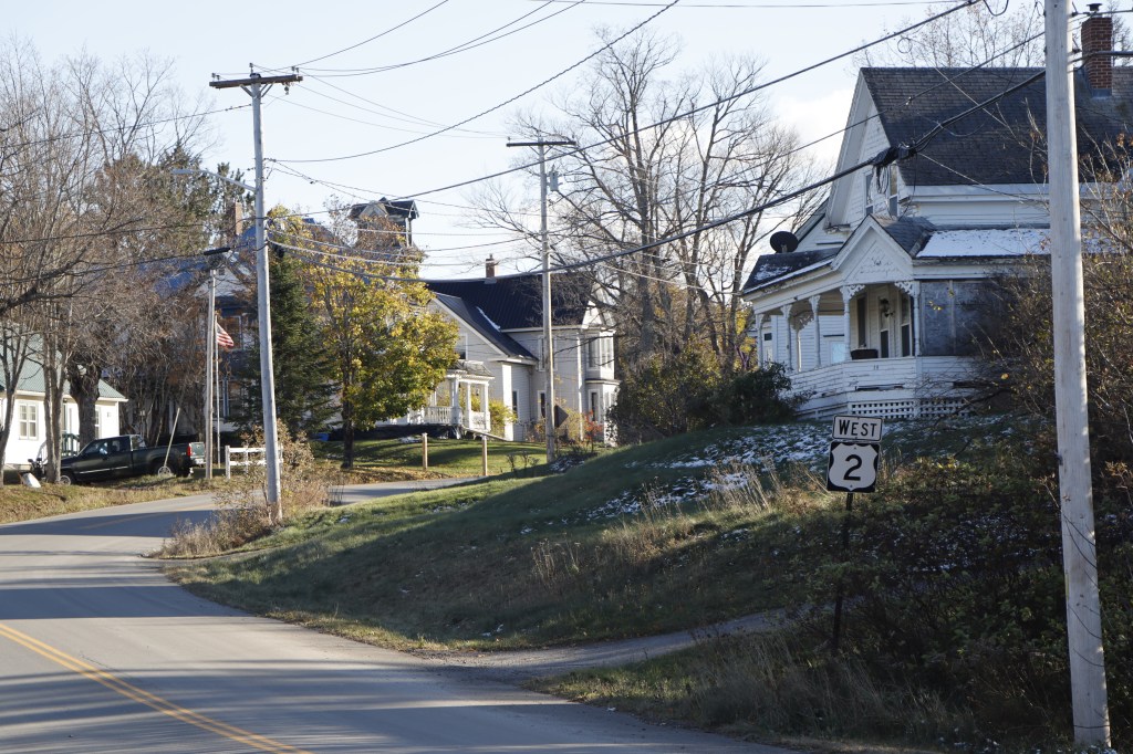
After this, the route meets up with its sister road, US Route 1, for just one mile. This is the only place in the US where these two roads meet, before 1 travels south to Florida and 2 travels west to Washington. Houlton celebrates this as a meeting point, and a connecting link across the country.


Dyer Brook
For some time, Route 2 follows alongside interstate 90, as it moves west before its turn south towards the Penobscot Valley. But after a few small villages in the north, it reaches a peak in the small town of Dyer Brook.
The community’s titular church sits at this peak, overlooking the farms and windmills of the many hills surrounding it. Though its population hovers around just 200, it stands out on this road as a centerpiece at the northern tip of the Maine Highlands.


Island Falls
A bit further south from Dyer Brook sits the town of Island Falls. Just north of the town proper, I stopped at the Upper Messalonkee Lake to view the hills east of Dyer Brook from a more southerly perspective. Even late into the fall season, a few boats remained on the water, taking in the serenity of its flow.
In the town itself, I found myself admiring the unusual post office style they had. I’m used to Maine’s typical small, white, shingle-sided post offices present everywhere from Jackman to Winter Harbor, but this one features a brick facade. It’s small, it’s subtle, but in exploring so much of a state and seeing the same architecture everywhere, it’s a strong sense of identity to have a unique USPS building.
Route 2 turns south once again in Island Falls, but before I’m out of the town, there’s a bridge across its namesake. The Mattawamkeag River runs through here, and just meters away from the town center, it splits into two sets of rapids surrounding a small forested island. Though a the northern part of the fork is partially dammed off, it is largely untouched, and the smooth sound of the falls is left to permeate across the community.


Silver Ridge
Between Island Falls and Macwahoc, there’s a part of Route 2 that’s largely unused due to the route’s bypass back up to Houlton. Very few travel this stretch, or live on it to begin with, but it is (and I say this having driven more roads in Maine than anywhere else) perhaps my favorite section of road in the entire state.
To the west, Katahdin stands proudly. Route 2 runs along a ridge through the towns of Sherman and Silver Ridge that is at the perfect altitude to see the great mountain above the trees, and it is clearly seen in every opening along the road.
I stopped in a small cemetery in Silver Ridge, and took in what I consider to be its best view from anywhere. If you’ve looked at the first post on this blog, you’re likely to be familiar with an edited version of this section’s picture – this is that view.

As a small personal aside, earlier this month this region of Maine was the epicenter of a total solar eclipse which crossed the nation. I decided to return to this cemetery on Eclipse Day to watch it pass over Katadhin, and it was one of the best experiences I’ve had in my travels. Being a college journalism student, I ended up creating a broadcast project of the 4 minute event. I’ll link a clip of it on the One Road YouTube channel here soon to share, in video form, what that day was like.
Macwahoc
Further down on the abandoned road, I came across the small rest area of the Molunkus Stream. It’s clear that this stop has remained mostly untouched by anyone since the Route 2 bypass has been in use.
Still, the slightly overgrown stop had a beautiful view of its titular stream, and with not even a house in sight for miles in any direction, it had a sense of serene solitude that’s hard to find anywhere else in New England beyond the North Woods.


Lincoln
Lincoln is the largest town since Houlton on this stretch, and one which comes as the starting point to Route 2’s following of the Penobscot River.
The first glimpses of the river come from the village just north of Lincoln, that being a boat ramp in Winn. Route 2 follows several rivers on its New England Rin, but the Penobscot is the first major one it hits, and marks a move out of the farm country of southern Aroostook and into the more populated areas of Penobscot Valley.
In Lincoln proper, it’s hard to miss the centerpiece of the town: a massive loon statue situated at the major intersection of Routes 2, 6, and 155. On my post about Route 6, I couldn’t stop here due to construction throughout the whole town blocking most of its parking. But back in November, it was open as usual. Beyond the loon, I took a walk down to the shore of Mattanawock Pond, a beautiful mountainous view to the east of town. Lincoln exists not as a place to simply be driven through, but rather to be admired, and the design of everything here makes that very clear.


Old Town
The next big spot on the Penobscot that I got to was Old Town, the first of Penobscot County’s three mill towns and the northern entrance to the Bangor metropolitan area.
I started on the eastern side of the river in the town of Milford. Like Winn before it, I stopped at a public boat launch to take a look. This one had significantly more traffic; being this much closer to the city means there’s more cars on the road.
Crossing a bridge over the Penobscot, I got to take a look at the Old Town dam, a (as far as my research has led) still-in-operation power plant for the two sides of the river. Though its neighboring Veazie Dam to the south was deconstructed in 2013, this one still runs strong, powering a small but significant portion of Penobscot County.


Bangor
Finally, we reach the end of this half of Route 2 in the first of Maine’s cities, Bangor. After travelling through such rural landscapes up until this point, Bangor (and its northern neighbor Orono) offers a taste of city life, but holds with it its own personality as a sliver of history.
Many of Bangor’s architecture remains in its 19th-century style, with ornate brick structures and towering church steeples. The road west from the city center climbs up a large hill, and looking back gives a wonderful view of the whole town, including neighboring Brewer and the easterly mountains of the northern Downeast.


Past Bangor’s airport and the beginning of I-395, Route 2 curves west towards the New Hampshire border. Part two of this journey will release simultaneously with this post, and in it we will travel from the towns of the southern Highlands all the way to Gilead in Maine’s Lakes and Mountains region.

Leave a comment