In the village of Somesville, Maine, on the western half of Mt. Desert Island, sits perhaps the most interesting intersection in the state. My interest in this intersection doesn’t come from any of the surrounding landmarks, not the fire station in the northeast corner nor the theatre just east of that. Rather, what makes this intersection so interesting is the fact that right here is both the beginning and middle of Maine Route 102.
Route 102 starts here in Somesville, and moves east and back around through every major village on the west side of Mt. Desert Island, a region known to locals as the “Quiet Side.” It travels through Pretty Marsh, Seal Cove, Tremont and Southwest Harbor before meeting back up with its terminus and continuing north to the Bar Harbor villages of Town Hill and Red Rock Corner.
I drove this road on a cloudy day in early May, hoping to catch sights of both the grand mountains of Acadia National Park and some of the ominous foggy views that Downeast Maine is known for. Lucky for me, this day was perfect for seeing both.
This is my journey down Maine Route 102.
Pretty Marsh
From Somesville, the first place Route 102 passes through is the village of Pretty Marsh. This, like Somesville, is another part of the town of Mt. Desert, one of the four towns sharing land on Mt. Desert Island.
Much of the residences of Pretty Marsh are by the coast, leaving this inland road to be nearly exclusively bordered by nature. The road weaves its way through a small ridgeline east, winding through some northern extensions of Acadia and passing the northern tip of Long Pond.


Seal Cove
Seal Cove marks the entrance to the town of Tremont and the first time Route 102 gets a clear view of the mountains of Acadia.
I stopped by a small boat launch by the village’s namesake Seal Cove Pond to get a look at Great Notch to the east. The clouds were fairly low, meaning that the fog wasn’t right on the ground, blocking the view from the road but was low enough to obscure the highest parts of the notch and create a majestic view of the peaks poking into the sky.


West Tremont
Beyond Seal Cove is another small village like Pretty Marsh, this being West Tremont.
While the views weren’t quite as clear as they were one village north, West Tremont made up for that with the rural vibes it held. This is the Quiet Side for a reason; the communities here represent the quintessential small farming and fishing towns of the Downeast, far removed from the tourist town and multi-million-dollar mansions of eastern Bar Harbor.
I stopped by Hillrest Cemetery to walk around and take a look back at the road. It’s beginning to curve southwest, and soon we’ll reach the southern tip of the route before heading back north.


Bass Harbor
The next village is perhaps the most recognizable small community on the island, that being Bass Harbor. While Route 102 skips north of the town proper, it still offers some beautiful views of both the ocean to the south and the mountains to the north.
The border of the village of Bass Harbor is marked by a placard on its west overlooking the harbor itself. The sea is calm here, a cove unfazed by the tidal waves down south. And with the still water and cloudy skies comes a lake-like mirror effect, extending the trees across the harbor into a beautiful horizontal symmetry.
Beyond this, I found something a bit more confusing. Though in my research of this road, the only true terminus of Route 102 is at its north, a route sign signifies that the end is actually here, nearly at its geographic center. Though the western part of Route 102 is, in fact, a part of Route 102, this sign has caused many online sources to disregard all of the road up until now, including Wikipedia.
At the border of Southwest Harbor, I found a small trail north of the bridge between towns that led out into a marshy section of Acadia National Park. With one more view of Great Notch from the south, I got ready for the second half of this journey, where Route 102 goes through a major portion of Acadia.


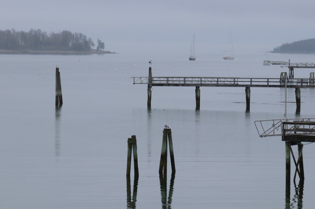
Southwest Harbor
But one last stop before the park proper that I had to make was in the town of Southwest Harbor.
Southwest Harbor is by far the largest community on the Quiet Side, and acts as the small tourist center for this half of Mount Desert Island. Though it doesn’t hold a candle in popularity to its northeast neighbor, Bar Harbor, its more hidden nature leads to an even better scenic location.
This is a fishing town at its core, built overlooking a harbor filled with docks and piers stretching deep into the water. I stopped in a small parking area on the edge of town to take in the view, met finally by the famed fog this island is known for.
The town proper, though much larger than any of the villages Route 102 has passed through thus far, still carries with it that signature small-town New England vibe.


Acadia
And finally, Route 102 properly enters what Mount Desert Island is best known for – Acadia National Park. This part of the road passes alongside Echo Lake, in between the two great peaks of the Quiet Side: the Beech and Acadia Mountains.
I decided to park and take a short hike east to the top of Acadia Mountain. Along the way, I stopped to look out over the trees west towards Beech Mountain and Great Notch, and see this half of the island from one of its highest points.
I’ll let the pictures speak for themselves on this part.


Somesville
Now back in the town of Mount Desert, Route 102 comes back to where it began, right here in the village of Somesville.
I stopped in the local theatre and made my way over to the intersection that first drew me here for One Road. I delved pretty deep into Maine’s geography, and this is the only numbered route I could find whose terminus intersects with itself, creating a closed loop. The scenic beauty of the island is wonderful, but it’s these small geographic anomalies that hold my biggest interests in this blog.


Town Hill
After completing its loop, Route 102 still has a little bit longer to go, and its last notable community is a village on the west side of Bar Harbor named simply Town Hill.
Town Hill is small, only hosting the local mainstays of a fire department, town store and local restaurant. We’re well north of Acadia now, but while this village doesn’t have many views of the park’s mountains, the road still weaves along ridges and through rocky forests until it reaches its end at the north.


Mt. Desert Narrows
Maine Route 102 ends here, at the sole bridge connecting Mount Desert Island to the mainland of Tremont to its north.
Looking out over the Mount Desert Narrows, I think back on the interest that led me to drive Route 102 in the first place. A small intersection, uninteresting to most, piqued my interest enough to drive along its route, and discover the beauty of a part of Maine that’s largely forgotten, even with its closeness to one of the state’s biggest draws in Bar Harbor and Acadia. Though tourist season will come soon, making the road to Mount Desert Island far harder to drive due to traffic, I’d highly recommend driving the Quiet Side in any season. It’s a small part of Maine that doesn’t seem to get enough love, but houses some of Acadia’s best, and quietest, views.


Leave a comment