At Route 6’s intersection with Interstate 95, the town of Howland sits quietly. A sort of in-between for travelers along the highway on their way north from Bangor, the town is little more than a junction stop for most. But today, it’s the start of the second half of my journey east, and the gateway to a section of Maine’s highlands that is nearly never seen.
This is the second part of my two-part series on Route 6. Make sure to read part one before moving to this part. It’ll still be here!
Howland
Across I-95 from Milo, I reached the town of Howland. This town acts as a small stop to those on the road between Bangor and Millinocket to the south and north, but also carries the unique role of being the meeting of the two largest rivers of the Highlands: The Piscataquis and the Penobscot.
Before crossing the bridge over the fork, I stopped at the town’s memorial right by the shore. The flatness of the land around the river makes for an incredibly far view along its stream, and the flow seems calm for two rivers as big as these.
Route 6 picks up 155 from the south here in Howland, and will continue following it through the towns of Enfield and Lincoln across the river. Unfortunately for me, Lincoln’s main street was under construction on the day I drove this, so I couldn’t stop to get another look at Mattanawcook Pond in the months since I drove US-2 (which intersects Route 6 here). Don’t worry though, the big loon is still safe and sound.


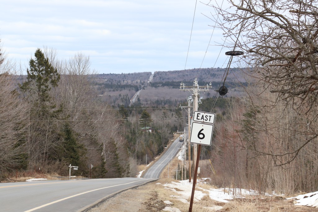
Springfield
Past Lincoln, the rest of Route 6 is one of the least travelled roads in the state. There’s no more big towns to be seen, and the last big geographic landmark won’t be for another 30 miles when we cross US Route 1. But, this emptiness leaves much of the rivers and hills surrounding this region completely untouched, save for the few small villages that dot the woodlands.
The first of those villages is Springfield. With a population of under 300, it’s still easily the largest town east of Lincoln. I stopped in the lot of a local storage facility situated atop the highest visible peak on the road, and admired the views to the east and west. When building this road, they were even nice enough to throw a couple route signs up here, making for a great picture to feature on a story about Route 6.
At the bottom of the valley, the tiny Mattagodus Stream has its start in a small roadside pond. This stream may seem insignificant, but it’s one of the many small sources that flow north to the Mattawamkeag, which drains back into the Penobscot. There’s a dirt pull-off here, where I stopped to get a look at the humble pond. I doubt many outside of Springfield and the surrounding villages even know what the Mattagodus Stream is, but its these tiny, forgotten spots that are what makes One Road trips so fun to drive.


Topsfield
After the unorganized township of Carroll Plantation, we reach the town that houses Route 6’s junction with Route 1. But before I get there, I have to make a quick pit stop at the last big lake I can see today.
East Musquash Lake is one of many big lakes in the valleys of the northern Downeast, but it’s uniquely the only one that Route 6 directly borders. The road snakes along its southern shore, leaving a few pockets of trees right at the waterline, but it often borders it directly with a small rock wall. There’s also a small boat launch by the shore, making for a nice rest area to stop and enjoy the beautiful scenery.


Vanceboro
Finally crossing US-1 in the east of Topsfield, Route 6 goes into its most remote part yet. There is virtually nothing from here to the Canadian border, outside of the few houses settled along an old freight railroad to the north. If you look at Route 6 on Google Maps, the road’s streetview hasn’t even been updated past Topsfield since 2011.
But at the end of this long-forgotten road sits the wonderful border community of Vanceboro. This town, being so far removed from the rest of Maine, has a visibly tight-knit vibe. The couple of people I met were incredibly friendly, and told me a little about the town’s place as one of Maine’s most rural border crossings.
Also, I can’t not mention the town’s unique welcome sign. Though I can see how the mannequins might be off-putting to some, I found a sense of local charm in their presence here that certainly nowhere else I’ve been has matched.
I stopped for gas in the town’s sole business, Hardwicke’s Country Store, and took a moment to walk through the town’s center to the very end of Route 6 at the Canadian border. Here, I’ve reached the eastern border of Maine, crossing through the entirety of the Highlands region as well as the northern reaches of Downeast and the Kennebec. This route is one of Maine’s most rural, crossing the north woods deeper than any other major road. But the tiny communities along its most remote parts house some of the best views in the state.


Leave a comment